cerro conico - 7451' - south ridge class 4
january 2023
After a visit to Futaleufu on my way down the Caraterra Austral, I was exposed to an entirely new area of the Patagonian mountains, and spent quite some time researhcing what some of the striking peaks we saw from the roads were. I was quite impressed with some of the rugged and steep mountains we saw. Upon looking thorugh the PeakBagger app to help with peak identifications, one that stuck out was Cerro Conico. Due to it having more than 5000 feet of prominence, it was shown, plus this peak towered above Futaleufu with great visibility just to the SE from most of the town. I did a deep dive onlne to see what I could find about it for potential routes but only found trip reports from climbers approaching it from the Argentina side. Apparently a nice hut is found at the edge of the glacier on the east side of the peak and it is commonly summitted by Argentenians utilizing a moderately technical rock climbing route. Since we were on the Chilean side however I wanted to find a way up from the west. After some time searching I found a WikiExplora post about someone who had hiked up to treeline from Rio Chico by parking on road W919 near its end where a private bridge crosses to the rovers east side at 750 meters elevation. We decided we would utilize this same approach as the user said the bushwhacking was manageable, so we parked in a small opening just off the road here, loaded up our packs for a single night and around mid morning we used this private bridge to cross the river.
We then followed along the bouldery riverbank for a few minutes, crossed over an old barbed wire fence, and located a dirt 4WD road that ascended gently into the mature Alerce forest. This road took us up for about 10-15 minutes to a prominent fork, where we stayed left and continued walking another 5-10 minutes to an old dilapidated cabin by a creek. There were a bunch of those annoying hitchhiker plants that clung to our pants and socks which rerquired great effort to remove. The Patagonian plants are pure evil! From the old cabin, we left the road and began walking straight uphill on the low angle slopes. The bush was mostly short shrubs and did not hinder progress too bad but some of them were thorny; par for the course in Patagonia. As we continued, we entered a section of more open but younger Alerce forest with little undergrowth. Here we began veering slightly right and away from the creek we had been loosely following until a steep berm to our right was reached. We made a steep but short 50 foot climb on loose dirt with veggie belays, then continued on a leftward ascending traverse through the forest up moderately steep slopes. The long curve to the south then back around that is shown on the WikiExplora map in the link above we found to be unnecessary and we just made for a straight line in a southeastward direction steadily gaining elevation. There was only one 200 foot section that had quite think brush where the trees dwindled, but this section can be avoided by continuing further left as you ascend instead of going higher up. Upon hitting a small dry ravine, this can then be followed straight up to treeline. We found this to be the best way. The trees get stunted and shorter with many interlocking twisted branches along the crest of a broad ridge for the final 200 or so feet to treeline. All bushes and trees abruptly ended at 1475 meters where a beautiful grassy flat spot just a couple minutes below the ridgecrest that makes an amazing campspot. Here we setup a camp and set up camp and took a nap as the time was too late in the day to attempt to keep going.
We then followed along the bouldery riverbank for a few minutes, crossed over an old barbed wire fence, and located a dirt 4WD road that ascended gently into the mature Alerce forest. This road took us up for about 10-15 minutes to a prominent fork, where we stayed left and continued walking another 5-10 minutes to an old dilapidated cabin by a creek. There were a bunch of those annoying hitchhiker plants that clung to our pants and socks which rerquired great effort to remove. The Patagonian plants are pure evil! From the old cabin, we left the road and began walking straight uphill on the low angle slopes. The bush was mostly short shrubs and did not hinder progress too bad but some of them were thorny; par for the course in Patagonia. As we continued, we entered a section of more open but younger Alerce forest with little undergrowth. Here we began veering slightly right and away from the creek we had been loosely following until a steep berm to our right was reached. We made a steep but short 50 foot climb on loose dirt with veggie belays, then continued on a leftward ascending traverse through the forest up moderately steep slopes. The long curve to the south then back around that is shown on the WikiExplora map in the link above we found to be unnecessary and we just made for a straight line in a southeastward direction steadily gaining elevation. There was only one 200 foot section that had quite think brush where the trees dwindled, but this section can be avoided by continuing further left as you ascend instead of going higher up. Upon hitting a small dry ravine, this can then be followed straight up to treeline. We found this to be the best way. The trees get stunted and shorter with many interlocking twisted branches along the crest of a broad ridge for the final 200 or so feet to treeline. All bushes and trees abruptly ended at 1475 meters where a beautiful grassy flat spot just a couple minutes below the ridgecrest that makes an amazing campspot. Here we setup a camp and set up camp and took a nap as the time was too late in the day to attempt to keep going.


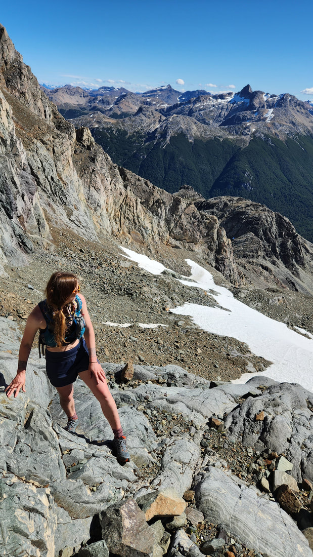
We hung out at camp a bit and decided to hike up towards the craggy towers and buttresses guarding the upper mountain to attempt to find a route. We continued back to the ridge and hiked up to the summit of a small rounded 1645 meter peak just above the camp area. This offered a stunning view of Cerro COnico west face, the Rio Chico valley and many other Chilean peaks to the west and north. We descended slightly and traversed onto the wide scree slopes on the lower west face and ascended class 2-3 rock steps up to the uppermost snowfield where a handful of options presented themselves. The summit we knew was above us to the left, and the south ridge seemed the most logical route from what we could see, but how to get onto the south ridge was a little elusive.
As the afternoon went on and the sun started getting low on the horizon, we opted to ascend scree rightward to a low saddle in the ridge where we could be able to cross to the east side and get a glimpse of the southeast side of the mountain, and hopefully a better look at the upper south ridge from the east. Upon reaching the saddle (which was the international border) we were greeted with a stunning view into Argentina. A low angle glacier terminated right at the saddle on the east side and allowed us to easily walk on soft snow until we got a great view of the SE face of Cerro Conico. This would be Bri's first steps into Argentina ironically enough. The SE face looked imposing, and certainly no way to feasibly access the south ridge from this far down, as steep cliffs and gendarmes guarded the lower ridge. We admired the views for a bit, and Bri did some headstands in the evening sunlight. As we started back down we noticed a low notch at roughly the midpoint of the south ridge that offered a potential 4th or low 5th class route to at least get to the south ridge. We decided to try that the following morning, and hiked back to our camp for the night.
As the afternoon went on and the sun started getting low on the horizon, we opted to ascend scree rightward to a low saddle in the ridge where we could be able to cross to the east side and get a glimpse of the southeast side of the mountain, and hopefully a better look at the upper south ridge from the east. Upon reaching the saddle (which was the international border) we were greeted with a stunning view into Argentina. A low angle glacier terminated right at the saddle on the east side and allowed us to easily walk on soft snow until we got a great view of the SE face of Cerro Conico. This would be Bri's first steps into Argentina ironically enough. The SE face looked imposing, and certainly no way to feasibly access the south ridge from this far down, as steep cliffs and gendarmes guarded the lower ridge. We admired the views for a bit, and Bri did some headstands in the evening sunlight. As we started back down we noticed a low notch at roughly the midpoint of the south ridge that offered a potential 4th or low 5th class route to at least get to the south ridge. We decided to try that the following morning, and hiked back to our camp for the night.